Tucked into Bankhead National Forest, you'll earn your trip to Sougahoagdee Falls with a 4.5 mile hike, but you do get to see several smaller falls on the way in to break up the trek.
At a Glance
- 4.5 mi round trip
- Nice View
- Kids OK
 Dogs OK
Gear: Our favorite snacks (like these nut butter bars) and camera gear
Gallery: Check out the pictures here
Sougahoagdee Falls - Trip Details
Most trips into Soagahoagdee Falls follow Brushy Creek in north of the bridge on Hickory Grove road. Plan for creek crossings, deadfall, and some difficult terrain as this is an unmarked, unimproved trail.
If you're hiking this trail in the shoulder seasons or after a lot of rain, expect to see several falls off of the canyon walls on the way in. The hike is an attraction all on its own.
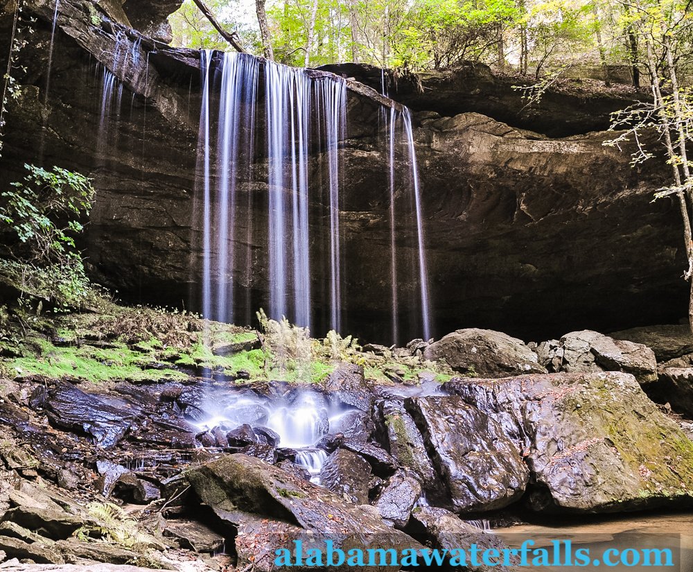
At the fall, the surrounding moss in the bowl at the falls is quite a scene once it greens up in warm weather. The waterfall is about 30 feet tall and doesn't carry the kind of volume that you'll see at larger falls like Desoto Falls and Noccalula Falls after rains.
More Waterfalls around Bankhead National Forest
Bankhead National Forest and the Sipsey Wilderness are full of opportunities for hikes and waterfall viewing. Near the Sipsey River, you can find Mize Mill Falls and Turkeyfoot Falls.
Further southwest on Cranal Road, you can head north of the road down Eagle Creek to see Eagle Creek Falls. Following the creek, you can also make your way further into the wilderness to see Deer Skull Falls and Little Ugly Falls.
On the southwestern edge of Bankhead National Forest, one of the most well-known waterfalls in the state is Caney Creek Falls. There are actually two falls in this area, but the lower falls are much further downstream than the upper falls.
Also nearby is the Parker Cascades, also known as Parker Falls and Kinlock Falls, a popular summer swimming hole just off of Kinlock Road.
East of the Sipsey River, Holmes Chapel Falls and Coal Mine Branch Falls are just south of Brushy Lake.
Sougahoagdee Falls Map, Directions, and Resources
Directions
Get DirectionsParking
-GPS Coordinates
34.253889, -87.264167
Weather - Upcoming Forecast
Don't get lost in the woods!


2 Comments on “Trip Guide to Sougahoagdee Falls in Bankhead National Forest”
I grew up in Walker County but lived away from Alabama for many years. We have retired back to the land where I grew up. We have 4 children, 13 grandchildren and almost 9 great-grandchildren. Back in December, one of our daughters, her husband, 3 of their 6 children and 5 of their grandchildren came to visit. We took the Caney Creek hike and it was perfect for the youngest great-grandchild who was nearly 3 and our son-in-law who is dealing with congestive heart failure and kidney disease. I am 79 and my husband is 80 but we are both in good health. The hike was perfect because it was an old logging road and not a difficult path. Also, the distance was perfect for all of us. I understand that there is a problem with parking for that hike at this time and that it is not open to the public right now. I don’t know if this is correct or not. The 2nd week of May we are expecting another daughter, her husband, and their 3 children and a daughter-in-law who will be about 7 months pregnant and they have a 2-year old. We have had another hike recommended but don’t know if it is appropriate for this group. That is Sougahoagdee Falls. We will be driving from Jasper and I understand that is about an hr. Can you give me some feedback on the hike? Thank you.
You should be fine on the Sougahoagdee Falls hike. The trail is relatively flat along the creek with no climbing in and out of canyons, as is common in this part of the state. And, the trail is well-traveled to the falls. The amount of water can drop quite a bit later in the year, but you should be fine in early May. You’ll be on a dirt/gravel road to get to the trailhead, but it was in good shape when I was there earlier this spring so you’ll be OK taking whatever you travel in.